Blog 8: Co-Designing the Website
The Bristol Quiet Areas Plan was never intended to be simply a map. From the outset, the project sought to understand how neurodivergent people prepare for, navigate and experience outdoor spaces. To achieve this, the website design was informed by four overlapping sources:
- Existing accessibility and neurodiversity guidance
- Examples of sensory mapping and inclusive visitor information
- A pan-disability accessibility audit undertaken by WECIL
- Co-design workshops and soundwalks with participants
Rather than relying on a single source of information, the project combined technical guidance with lived experience to shape the final website design.
Learning from Existing Examples
One of the first challenges was the lack of established examples of outdoor sensory mapping.
Most available examples focused on museums, visitor attractions and indoor environments. To understand what worked well, the project reviewed examples including KultureCity, Birmingham Museums, The Wallace Collection, Winchester Science Centre and the University of Bath Fresh Shop sensory map. These examples provided useful precedents for sensory information, social stories, route guidance and accessible communication.
Participants strongly preferred the KultureCity approach, particularly its use of photographic social stories, visual journeys and practical information that helped reduce uncertainty before arrival. One participant commented:
I really, really struggle to enter spaces if I’m not aware of what it looks like.
The Birmingham Museums sensory maps were also positively received because of their simplicity, limited number of symbols and clear visual hierarchy. In contrast, examples with large numbers of icons, low colour contrast or complex map keys were considered more difficult to use. Participants frequently reported needing to look back and forth between maps and legends, increasing cognitive load.
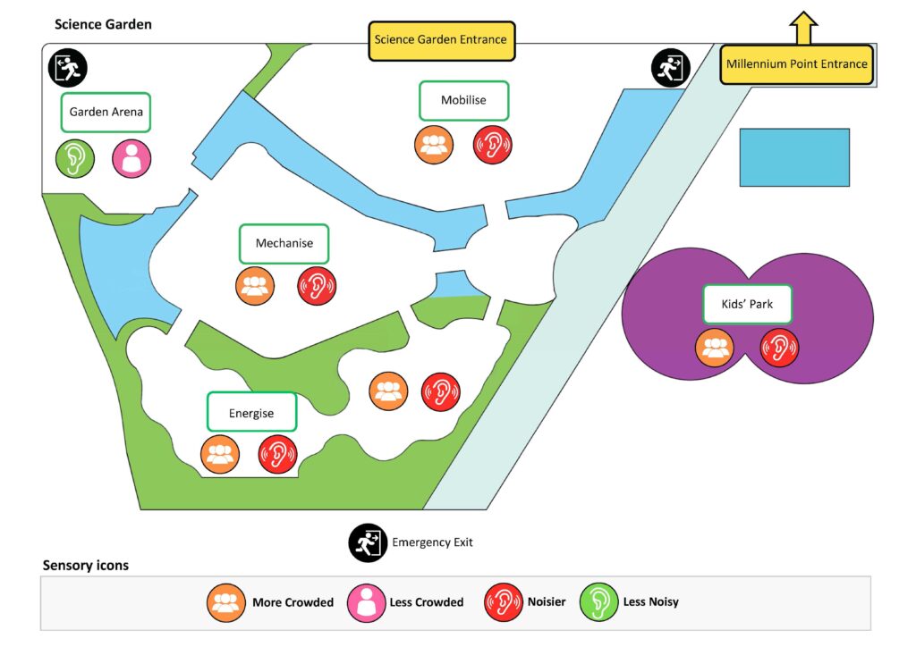
The Winchester Science Centre examples also influenced the project by demonstrating the value of softer graphics, sketch-style illustrations and highlighting key points of interest rather than attempting to map everything.
The Accessibility Audit
Alongside participant engagement, WECIL undertook a detailed access audit of the three pilot quiet spaces. The audit considered the entire visitor journey, including arrival routes, wayfinding, surface quality, seating, sensory conditions, toilet provision and user confidence. Importantly, it recognised that uncertainty and inconsistent information can be as disabling as physical barriers.
The audit highlighted issues that conventional mapping would often overlook:
- The best route into a site was not always the most obvious route
- Accessible facilities were sometimes difficult to locate
- Surface conditions changed seasonally
- Seating quality and accessibility varied considerably
- Opening times and operational arrangements were not always clear
- Some spaces functioned better as routes through than places to dwell
- Predictability and reliability were critical factors in user confidence
These findings directly informed the information presented on the website and social stories.
Mapping the Journey, Not Just the Destination
One of the clearest messages from both the workshop and the accessibility audit was that users needed information about the journey as much as the destination.
As a result, the website moved beyond a traditional location map and incorporated:
- Best entrance points
- Step-by-step routes from approximately 50 metres away
- Photographs showing what users would see
- Seating locations
- Toilet information
- Landmark references
- Information on shade, smells and sensory conditions
- Route guidance back to the city centre
This approach reflects a shift from mapping places to mapping experiences.
Why Social Stories Became Central
Perhaps the most significant design decision was the inclusion of social stories.
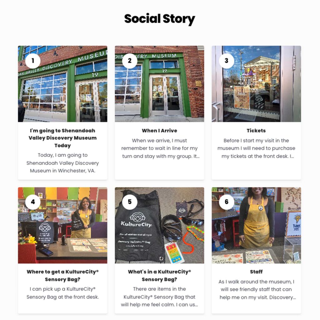
- I’m going to Shenandoah Valley Discovery Museum today. Today, I am going to Shenandoah Valley Discover Museum in Winchester, VA.
- When I arrive. When we arrive, I must remember to wait in line for my turn with my group.
- Tickets. Before I start my visit in the museum I will need to purchase my tickets at the front desk.
- Where to get a KultureCity Sensory Bag? I can pick up a KultureCity Sensory Bag at the front desk.
- What’s in a KultureCity Sensory Bag? There are items in the Kulture City Sensory Bag that will help me feel calm.
- Staff. As I walk around the museum, I will see friendly staff that can help me on my visit.
Workshop participants consistently prioritised predictability, preparation and reassurance. Photographs of routes, entrances, benches and key landmarks helped users understand what to expect before arriving. Participants repeatedly stated that knowing what a place looked like in advance increased their confidence and reduced anxiety.
As a result, social stories became one of the project’s most important outputs. Each story combines photographs with simple first-person descriptions, allowing users to mentally rehearse their visit before travelling.
Designing for Accessibility
The project also used an AI agent as a critical friend. The Agent was created and informed in line with wider accessibility standards and guidance, including the Equality Act 2010, WCAG 2.1, PAS 6463: Design for the Mind, National Autistic Society guidance, Design Council Inclusive Design Principles, and RNIB accessibility guidance.
Accessibility guidance, workshop findings, accessibility audit outcomes, draft site plans and website proposals were uploaded into a project knowledge base and used to review emerging designs. This provided an additional layer of critique and helped test proposals against both published guidance and participant feedback, while keeping decision-making firmly within the co-design process.
These principles influenced several design decisions:
- Simple page layouts
- Individual pages for each quiet space
- Minimal visual clutter
- Clear colour contrast
- Avoidance of red and green colour combinations
- Limited number of icons
- Alt text for all images
- Screen reader compatibility
- Plain language and predictable navigation
The project also used an AI agent as a critical friend throughout the design process. Accessibility guidance, sensory mapping examples, workshop outcomes, accessibility audit findings, draft site plans and website proposals were uploaded and used as a knowledge base against which emerging designs could be reviewed. This provided an additional layer of critique, helping identify potential gaps and opportunities. However, recommendations were always tested against participant feedback and lived experience, ensuring that final decisions remained grounded in the co-design process.
Importantly, these features were not added as accessibility extras. They became the foundation of the website design.
From Maps to Confidence
The project ultimately found that neurodivergent mapping is not primarily about geography.
Maps tell people where a place is.
Neuroinclusive information helps people understand what will happen when they get there.
By combining sensory mapping, accessibility auditing, social stories, wayfinding information and participant feedback, the Bristol Quiet Areas Plan developed an approach that prioritises confidence, predictability and preparation. In doing so, it suggests that the future of accessible mapping may lie not in creating more complex maps, but in creating richer, more human-centred information about places.
References
- Autistica. Creating Autism-Friendly Environments.
- British Standards Institution (2022). PAS 6463: Design for the Mind – Neurodiversity and the Built Environment.
- Centre for Accessible Environments. Inclusive Wayfinding Guidance.
- Design Council. Inclusive Design Principles.
- Equality Act 2010.
- International Organisation for Standardisation. ISO 12913 Soundscape Series.
- National Autistic Society. Autism and the Environment Guidance.
- Public Sector Bodies (Websites and Mobile Applications) Accessibility Regulations 2018.
- Royal National Institute of Blind People (RNIB). Accessible Information and Digital Accessibility Guidance.
- World Wide Web Consortium (W3C). Web Content Accessibility Guidelines (WCAG) 2.1.
- Social Stories Carol Gray https://carolgraysocialstories.com/
Case Studies Reviewed
- Birmingham Museums. Sensory Maps.
https://www.birminghammuseums.org.uk/thinktank/visit/accessibility/sensory-map - KultureCity. Sensory Inclusive Venue Guides.
https://venue.kulturecity.org/venues/shenandoah-valley-discovery-museum - The Wallace Collection. Sensory Maps.
https://www.wallacecollection.org/documents/1240/Sensory_Map_Housekeeping_Light.pdf - University of Bath. Fresh Shop Sensory Map.
https://www.bath.ac.uk/publications/fresh-shop-sensory-map - Winchester Science Centre. Accessibility Maps and Visitor Information.
https://www.winchestersciencecentre.org/visiting/know-before-you-go/maps